Welcome to the Boulevard Project Sub-site
Why Boulevard?
Boulevards are pleasant places to spend time – on foot, on bikes, in and outside cafes, restaurants and shops, surrounded by greenery – but they are also busy streets, carrying large amounts of traffic. A boulevard is not a pedestrian precinct, but is a place where there’s a better relationship between motorised traffic and people wanting to enjoy being in the street.

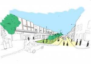
What if the parking outside the Broomhill shops was turned into a green zone with trees, and the pedestrian zone was improved?
Where?
The corridor between Ranmoor/Endcliffe and Weston Park/Sheffield University, where walking as a means of travel is already commensurate with car travel and there is the opportunity to premote active travel further with benefits to both health and the environent.
What’s the vision?
A street with a real sense of place in which to walk, cycle and enjoy outdoor city life whilst continuing to accomodate traffic, albeit at lower speeds, with lower pollution levels, and with much less detriments to the street scene.
What do we hope to achieve?
- A much more attractive shopping centre in Broomhill for both visitors and buisnesses
- Air quality up to European legal requirements
- More pleasant walking conditions, encouraging more people to do it
- Safer and more pleasant cycling conditions, encouraging more people to get on a bike
- A contribution to the improvement of Public Health by premoting active travel
- Promotion of Sheffied as the “Outdoor City”, by better linking Weston and Endcliffe Parks and ongoing routes into the Peak District
- A better setting for the many buildings that form the Broomhill Conservation Area
- Conditions in which drivers of cars, vans, lorries and buses, and also cyclists, concede greater priority to pedestrians seeking to move along and to cross the street
- A decrease in the number and severity of road accidents
How and Why?
You can read more about our plans and view our interactive map on the Boulevard Plan page.
Walking & Cycling
There are some routes through the area where people walk or cycle away from traffic, but because the main roads are often the most direct and easiest routes, avoiding the steepest hills, and because many important destinations are on these routes, it’s here that the majority of people walk and cycle and will continue to want to do so.
| Main Walking Routes | Main Cycling Routes |
Travel In The BBEST Area
- 74-76% of students travel to the University on foot as their “main mode of transport”. 4% travel by cycle.
- 24% of staff travel to the University on foot, and 8-9% by cycle.
- University Travel Surveys, 2010 and 2012
- For students the average distance per person per day on return trips is 2.5 miles for walking and 4.3 miles for cycling.
- For staff the average distance per person per day on return trips is 8 miles for cycling.
- University Travel Survey 2012
- In Sheffield as a whole, for return journeys to work between 4 and 10 km in length (2.5-6.2 miles), walking (9.3% of all work journeys) is preferred to cycling (3.2% of total).
- Office for National Statistics: 2011 Census Analysis – Cycling to Work
- Just 1% of all vehicular traffic on the main route through the corridor is pedal cycles.
- Census points on Whitham Road and Fulwood Road, 2000-2012
- Pedestrian volumes in the BBEST corridor are of a similar order of magnitude to car volumes.
- Sheffield City Council Annual Cordon Counts 2005-2014, Hospitals/University/Museums 5 point survey (Table below)
See below a multi-layered map of identified problems and our ideas for improvements that can turn an anonamous, traffic-dominated road into an attractive street with a real sense of place.
We welcome your comments during the consultation on our main plan.
The Boulevard Project group have undertaken a number of activities including traffic counts.
We will be uploading a number of videos soon that were taken when the traffic lights in Broomhill failed in February 2016.
We would like to thank the following organisations for their help and support in developing the Boulevard Project:
- Sustrans
- Sheffield City Council Directorate of Place
- Sheffield University
- Destination Broomhill


